Jump to Winery List
Grampians Wine Region
The Grampians Wine Region, in Western Victoria centred around the township of Stawell, Halls Gap, Ararat, Moyston, Mafeking, Maroona, Willaura, dates back to the 1860’s when two pineers wineries The Blampieds and the Bests established vineyards at Great Western. Tunnels dug by the Gold Miners in there area were used as cellars for matuyring and storing sparkling wine maturation. A variety of table wines are also produced, including Shiraz, Rieslings, Pinots and recent plantings of less traditional varietals.The nearby Grampians National Park is a wonderful area for scenic drives, native wildlife, bushwalking and rock climbing are also popular. The landscape are is varied, ranging from the foothills the Grampians themselves at Halls Gap, to the hillsides of Mount Ararat. and Mount Langi Ghiran
and then to the gentle rolling slopes around Great Western and Stawell. The sites need to be carefully selected
to deal with Spring frosts and water availability. The Grampians region has a generally cooler climate than
areas to the east such as the Pyrenees and Bendigo Regions. Altitude and aspect are especially important,
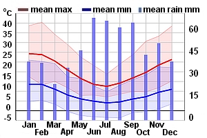
producing significant local climatic variation. Generally rainfall is very low during the growing season
throughout the entire region and irrigation is essential for economic yields. Annual rainfall: 590 mm;
Mean January temp: 20.2°C; Sunshine hours per day: 8.3.
The Grampians Wine Region includes two districts :
Halls Gap ;
Ararat
Search for a Winery
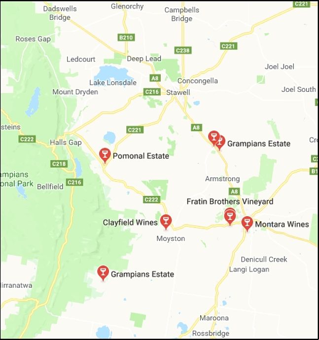
- ATR Wines, VIC
- Best`s Great Western, VIC
- Boroka Vineyard, VIC
- Clayfield Wines, VIC
- Donovan Wines, VIC
- Fallen Giants Vineyard , VIC
- Fratin Brothers, VIC
- Grampians Estate, VIC
- Kimbarra Wines, VIC
- Mount Ararat, VIC
- Mount Chalambar, VIC
- Mount Langi Ghiran, VIC
- Mountainside Wines, VIC
- Norton Estate Wines, VIC
- Pomonal Estate, VIC
- Seppelt -Great Western, VIC
- The Gap, VIC
- Westgate Vineyard, VIC
No Match for Your Search